
The scenery for the predecessor of the Microsoft Flight Simulator was very primitive. The flying area was a flat line-drawn grid. There were "mountains" along the perimeter, but you could not fly over them. They were just a backdrop.
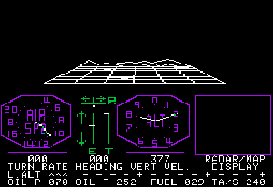 This 6X6 grid was your world. This 6X6 grid was your world. |
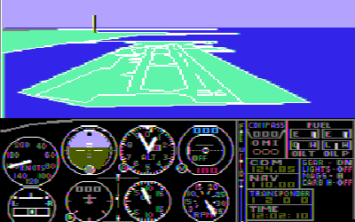 Landing at Meigs Field in Chicago. Landing at Meigs Field in Chicago. |
The Microsoft Flight Simulator (MSFS) added colors and primitive hills. The colors were simple: green for ground, dark blue for water and light blue for sky. There were a few 3D objects. The flight instruments took up half the screen, which improved speed by reducing the size of the 3D area.
Over time, MSFS added 3D terrain mesh (bgl) files and overlaid that mesh with texture files (dds files). Initially, both were fairly primitive. But they evolved over time into fairly detailed representations. The mesh and texture files have become fairly large and detailed and are probably the greatest reason for the slow speed at which some programs operate.
The FSX version divided the world into grids of 1.2 km (about .75 miles). The default textures were 1024x1024, which means they had a resolution of about one pixel = 4 feet. The mesh files had a lower level of resolution of 1 point every 40 meters (about 131 feet). The texture resolution was increased for places where you would be near to the ground, as with an airport. Creating maps and textures was very time-consuming. Microsoft attempted to simplify the process by dividing the world into various zones with different kinds of terrains. But the hours spent creating all these textures must have been enormous. There were about 7 textures per zone. These were designed so that that the textures could be arranged in any order and the edges would match.
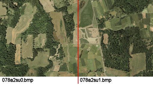
FSX allowed users to create custom meshes. FSX used mesh data equivalent to a 40m DEM (one point every 40 meters). However, users could creates meshes based on 10 meter DEMs. Users could obtain texture data from Google or Bing maps or other satellite. However, this data generally had to be modified by hand.
MSFS 2020 automates the process, automatically obtaining both the mesh and texture data from Bing maps. However, hand-crafting is still necessary because satellite images have problems with steep vertical surfaces and buildings. This has created some strange artifacts.